Mission
Instrument
TES Instrument Specifications
TES was a high-resolution, infrared, imaging Fourier-transform spectrometer with spectral coverage of 650 to 2250 cm-1 at a spectral resolution of 0.1 cm-1 (low resolution) or 0.025 cm--1 (high resolution), offering line-width-limited discrimination of essentially all radiatively active molecular species in Earth's lower atmosphere.
| Requirement | Specification | Comments |
|---|---|---|
| Spectrometer type | Connes-type four-port Fourier transform spectrometer | Limb and nadir viewing capability |
| Spectral sampling distance | Interchangeably 0.0592 cm-1 nadir and 0.0148 cm-1 limb | Unapodized |
| Optical path difference | Interchangeably ±8.45 cm nadir and ±33.8 cm limb | Double-sided interferograms |
| Overall spectral coverage | 650-3050 cm-1 (3.2-15.4 µm) | Continuous but with multiple sub-ranges typically 200-300 cm-1 wide |
| Individual detector array spectral coverage (cm-1) | 1A (1900-3050), 1B (820-1150), 2A (1100-1950), 2B (650-900) | All mercury cadmium telluride photo voltaic at 65 K |
| Detector array configuration | 1 X 16 | All four arrays optically conjugated |
| Aperture | 5 cm | Unit magnification system |
| System étandue (per pixel) | 9.45 X 10⁻⁵ cm2sr | Not allowing for a small central obscuration from the Cassegrain secondaries |
| Modulation index | >0.7; 650-3050 cm-1 | >0.5 at 1.06 µm (control laser) |
| Spectral accuracy | ±0.00025 cm-1 | After correction for finite field of view, off axis effects, Doppler shifts, etc. |
| Channeling | <10% peak to peak; <1% after calibration | All planar transmissive elements wedged |
| Spatial resolution | 0.5 X 5 km nadir; 2.3 X 23 km limb | |
| Spatial coverage | 5.3 X 8.5 km nadir; 37 X 23 km limb | |
| Pointing accuracy | 75 µrad pitch, 750 µrad yaw, 1100 µrad roll | Peak-to-peak values |
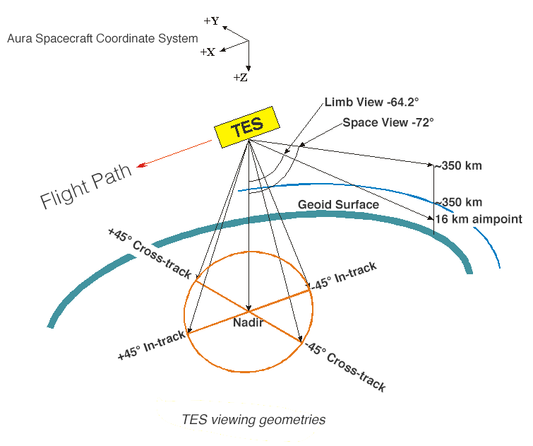
| Field of regard | 45° cone about nadir plus trailing limb | Also views internal calibration sources |
| Scan (integration) time | 4-s nadir and calibration, 16-s limb | Constant-speed scan, 4.2 cm/sec (optical path difference rate) |
| Maximum stare time, nadir | 208 s | 40 downlooking scans |
| Transect coverage | 885 km maximum | |
| Interferogram dynamic range | < 16 bits | Plus four switchable gain steps |
| Radiometric accuracy | < 1K, 650-2500 cm-1; < 2 K, 2500-3050 cm-1 | Internal, adjustable, hot blackbody + cold space |
| Pixel-to-pixel cross talk | <10% | Includes diffraction, aberrations, carrier diffusion, etc. |
| Spectral signal-to-noise ratio | As much as 600:1; 30:1 minimum requirement | Depends on spectral region and target. General goal is to be source photon shot-noise limited |
| Lifetime | 5 years on orbit | Plus 2 years before launch |
| Size | 1.0 m X 1.3 m X 1.4 m | Earth shade stowed |
| Mass | 385 kg | Allocation |
| Power, average | 334 W | Allocation |
| Power, peak | 361 W | Allocation |
| Data rate, average | 4.5 MBPS | science only |
| Data rate, peak | 6.2 MBPS | Allocation |
TES Optical Filters
The following table lists the optical-filter specifications and species in the atmosphere having absorption/emission features in the filter spectral ranges. Not all the filters are used in the global survey. Filters 2B1, 1B2, 1A1, and 2A1 were used in nadir global surveys, and filters 2B1, 1B2, 1A1, 2A1, 1B1, and 2A4 were used in limb global surveys.
| Filter Identification | Filter Half-Power Points (cm-1) | Major Species | |
|---|---|---|---|
| Array 2B (650 - 900 cm-1) | |||
| 2B1 | 650 | 900 | CO2, HNO3, CFC11, NO21,> |
| Array 1B (820 - 1150 cm-1) | |||
| 1B1 | 820 | 1050 | HNO3, NH3, CFC11, CFC12, O32,> |
| 1B2 | 950 | 1150 | O3, NH3, CFC11, CFC12, N2O |
| Array 2A (1100 - 1950 cm-1) | |||
| 2A1 | 1100 | 1325 | O3, N2O, HNO3O, CFC12, SO2, CH4 |
| 2A2 | 1300 | 1550 | O3, HNO3, CH4 |
| 2A3 | 1500 | 1750 | H2O, NO2O,> |
| 2A4 | 1700 | 1950 | H2O, NO |
| Array 1A (1900 - 3050 cm-1) | |||
| 1A1 | 1900 | 2250 | O3, CO, N2O, NO, OCS |
| 1A2 | 2200 | 2450 | CO2, N2 |
| 1A3 | 2425 | 2450 | N2O |
| 1A4 | 2600 | 2850 | HDO |
| 1A5 | 2800 | 3050 | CH4, HCl, O3 |
Orbit & Coverage
Orbit
The Aura satellite orbited 438 miles (705 km) from Earth's surface during the TES mission. Its inclination (the angle between the orbit plane and the equator plane) was 98.21°. The orbit was sun-synchronous with a 1:43 PM ascending node.
Target Size
One of the features of a Fourier Transform Spectrometer (FTS) is that it readily supports an imaging mode, which, in turn, improves collection efficiency compared with the more traditional spatially scanning systems. TES employed 1 X 16 linear arrays, each of whose individual field of view was 0.75 X 7.5 mrad.
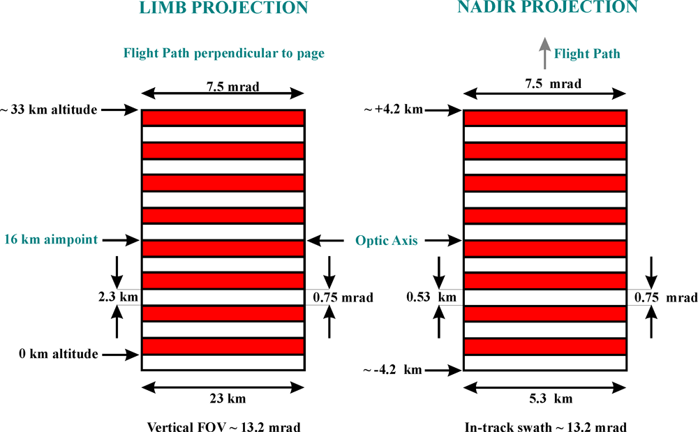
At the trailing limb, some 3100 km distant, these values translated to spatial resolutions of 2.3 km vertically and 23 km horizontally. Since the same arrays are used in nadir (705-km range), the projections become 0.5 km in-track and 5 km cross-track at the Earth's surface.
Nadir View
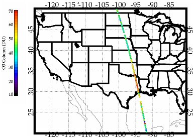
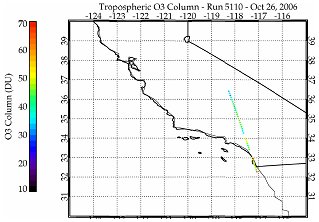
The nadir mode was able to look at an area approximately 5.3 km x 8.3 km (3.3 x 5.2 miles) with a spectral resolution of 0.1 cm-1 (low-resolution mode). TES was a pointable instrument and could access any target within 45 degrees of the local vertical and produce regional transects up to 885 km in length without any gaps in coverage.
Limb View
The TES limb mode was able to look at an area approximately 26 km x 41.8 km (16.2 x 25.9 miles) with a spectral resolution of 0.025 cm-1 (high resolution mode). In the limb mode, TES had a height resolution of 2.3 km, with coverage from 0 to 33 km.
The at-launch version of the global survey consisted of four ground locations, two co-located nadir targets and three limb tangents projected to the ground. On May 25, 2005 the global survey was modified to conserve instrument life. The three limb scans were eliminated from the sequences and replaced by an additional nadir scan.
TES Nadir Observation Footprint Examples
Special observation Step & Stare footprint (these were about 45 km apart)
Transect observation (about 12 km apart)
Ground targets for a TES global survey period of 16-orbit (~26 hours). Global surveys were about 180 km apart.